Forest Service Announces Prescribed Burns for Autumn
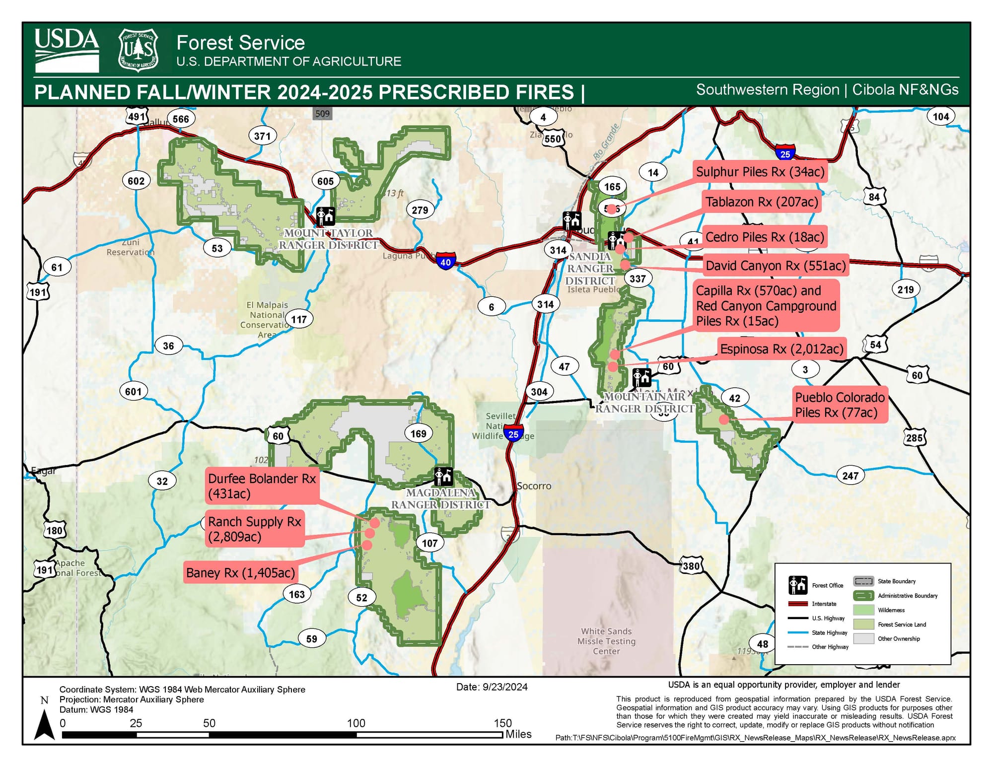
At the September 24, 2024, meeting of the Torrance County Local Emergency Planning Committee, US Forest Service representative Christian Larson identified two possible prescribed burns for Autumn in the Torrance County area. A press release published by the New Mexico Fire Information website provided additional details regarding seven prescribed burns that will have an impact on the East Mountains region. The US Forest Service plans to start prescribed burns as early as October 14, 2024, although the start dates can change due to weather conditions or administrator approval. There are no specific dates provided for the prescribed burns discussed below.
Prescribed Burns Planned by the Mountainair Ranger District Impacting Southern Torrance County
The Mountainair Ranger District planned a 570-acre prescribed burn in the area of Capilla Peak, with smoke expected to be visible in Mountainair, Punta de Agua, Manzano, and throughout the Estancia Valley. The Mountainair Ranger District intends to conduct a 2,012-acre prescribed burn as part of the Espinosa-Barranco Wildlife Improvement Project eight miles northwest of Mountainair, with smoke visible in Mountainair, Punta de Agua, Manzano, and the Estancia Valley. The Mountainair Ranger District plans to conduct a 15-acre prescribed burn in the area adjacent to the Upper Red Canyon Campground in Manzano Mountains State Park. Finally, the Mountainair Ranger District has planned for a prescribed burn known as the Pueblo Colorado Piles Prescribed Fire, which will take place as part of the Coordinated Resource Management Project in the Gallinas Mountains southeast of Willard and 15 miles northwest of Corona. Smoke from this prescribed burn could be visible in the areas of Willard, Cedarvale, Corona, or within the Estancia Valley.
Prescribed Burns Planned by the Sandia Ranger District That Impact Northern Torrance County
The Sandia Ranger District has planned a 207-acre prescribed burn known as the Tablazon Prescribed Fire, which is located south of NM-333, the Lower Pine trailhead, and east of Forest Service Road 462. Smoke from this prescribed burn may be visible in Tijeras, Edgewood, and Moriarty. The Sandia Ranger District is also expected to conduct the David Canyon Prescribed Fire, consisting of 551-acres of burning in the Manzanita Mountains, west of NM-337 and the Mars Court Trailhead. Smoke from this prescribed burn may be visible in Tijeras, Edgewood, and Moriarty. The Sandia Ranger District is planning the Sulphur Piles Prescribed Fire, consisting of 34-acres of piles, north of I-40, west of NM-14, and south of NM-536. While this is north of I-40, smoke from the fire may be visible in the Tijeras, Edgewood, and Moriarty areas. The Sandia Ranger District has also planned the Cedro Piles Prescribed Burn, which would cover 18 acres of brush piles south of Forest Service Road 462 and east of NM-337, with smoke potentially visible in teh Tijeras, Edgewood, and Moriarty areas.
Those with questions or concerns regarding the prescribed burns can contact the Mountainair Ranger District Office at 505-847-2990, the Sandia Ranger District Office at 505-281-3304, or the Cibola National Forest and National Grasslands Supervisor Office at 505-346-3900.